
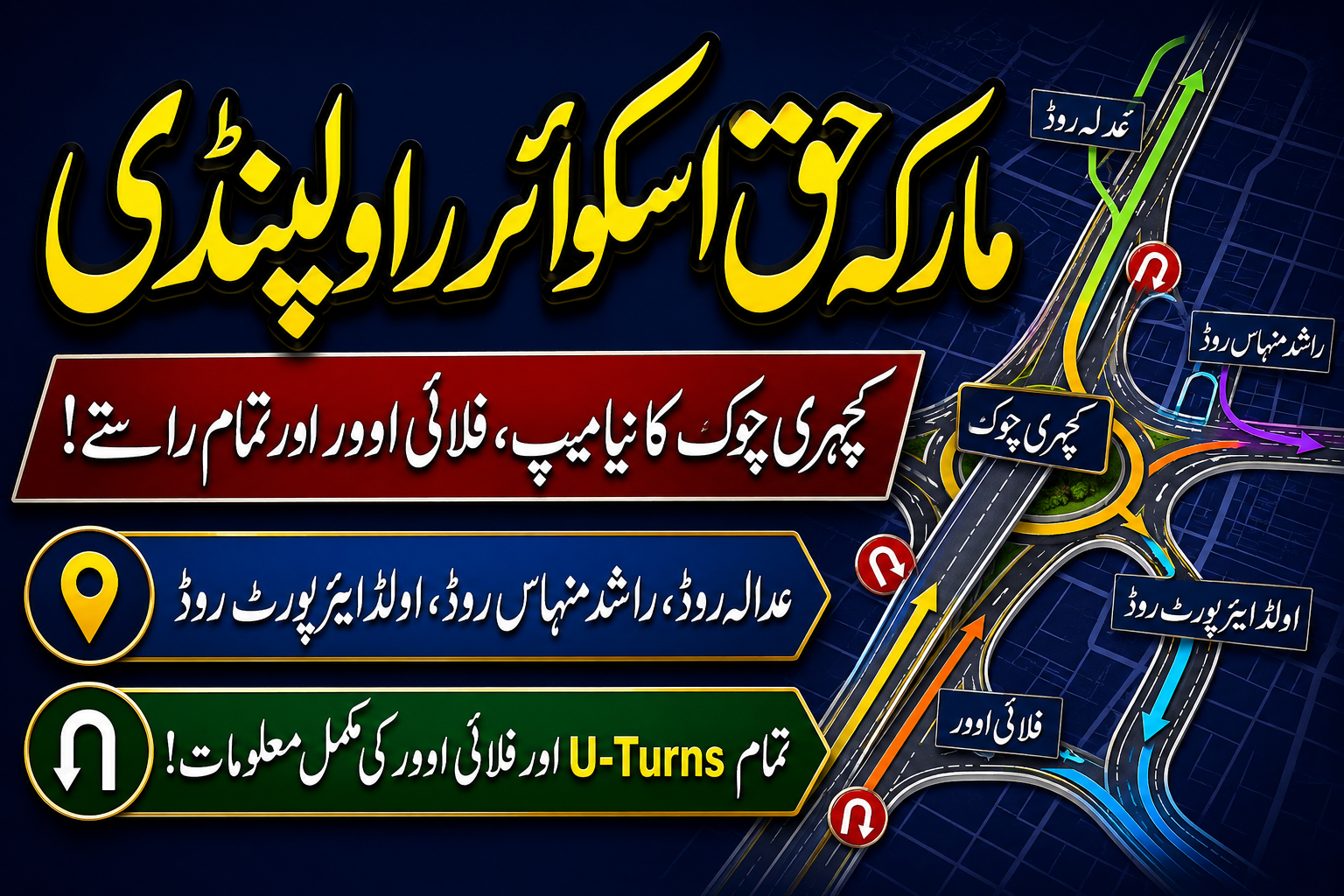
Rawalpindi serves as a vital urban and military hub in Northern Punjab, situated adjacent to Pakistan’s federal capital, Islamabad. At the heart of Rawalpindi’s complex road network lies one of the city’s busiest and historically significant traffic junctions: Marka-e-Haq Square. Historically known to locals and commuters as Kacheri Chowk due to its proximity to the District Courts, this intersection underwent a historic transformation and renaming to honor national pride and military heritage.
Today, Marka-e-Haq Square operates as a massive multi-tiered interchange system featuring elevated flyovers, underpasses, slip lanes, and grade-separated U-turns. It connects several arterial routes, including the N-5 national highway corridor, defense cantonment areas, educational institutions, judicial complexes, and dense residential zones.
Understanding the exact layout of Marka-e-Haq Square—from its intersecting roads and signal-free loops to the surrounding government offices and landmarks—is essential for commuters, commercial transport operators, visitors, and urban planning enthusiasts alike.
1. Major Road Networks Intersecting at Marka-e-Haq Square
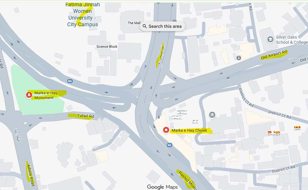
The Marka-e-Haq Square area functions as a central distribution node for traffic coming from Islamabad, the Rawalpindi Cantonment (Cantt), the judicial core, and major suburban expansions like Adiala Road.
                                  [ THE MALL / N5 NORTH ]
                                             │
                                             │
     [ ADIALA ROAD ] ─── (Tufail Rd) ─── [ MARKA-E-HAQ ] ─── [ OLD AIRPORT ROAD ]
   (Gorakhpur / Suburbs)                     SQUARE               (Gulzar-e-Quaid / HWY)
                                             │
                                             │
                                  [ RASHID MINHAS ROAD ]
                                   (Saddar / Cantt / N5)
A. Rashid Minhas Road (راشد منہاس روڈ)
- Location & Alignment: Map ke center mein shimal se junub ki taraf jane wali sab se aham aur bari sadak.
- Connectivity: This road directly links the commercial heart of Rawalpindi (Saddar) and the Cantonment zone to northern destinations leading toward The Mall, Peshawar Road, and Islamabad via the Grand Trunk Road (N-5).
- Traffic Role: Carrying heavy volumes of civilian, commercial, and military transport, this arterial corridor relies heavily on the elevated flyover structures at Marka-e-Haq Square to maintain continuous, signal-free traffic movement.
B. Adiala Road (عدالہ روڈ)
- Location & Alignment: Southwest side ka aik bada rasta jo shahri abadi aur Central Jail ki taraf jata hai.
- Connectivity: It connects southwest suburban populations directly to the central urban core of Rawalpindi.
- Traffic Role: Commuters traveling inbound on Adiala Road merge into Marka-e-Haq Square via dedicated slip roads and connecting links, allowing them to proceed toward Saddar, the District Courts, or the Islamabad highway network without bottlenecking the main square.
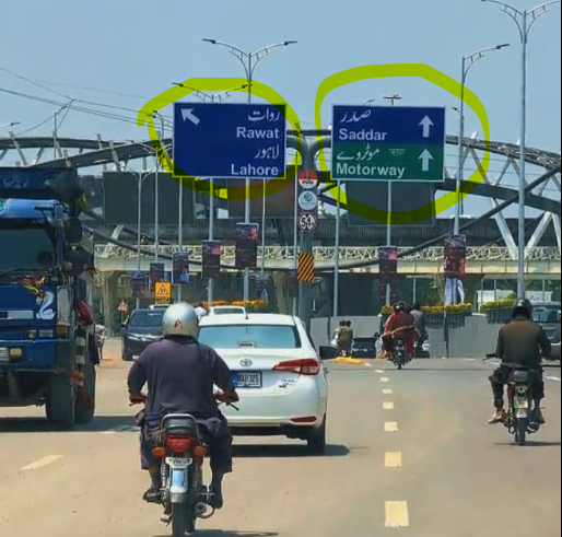
C. Old Airport Road (پرانا ایئرپورٹ روڈ)
- Location & Alignment: Branching off toward the upper-right (northeast) section of the map, Old Airport Road leads toward the historic Nur Khan Airbase (formerly Chaklala Airbase), Gulzar-e-Quaid, and eastern arterial corridors.
- Connectivity: Acts as a vital bypass for traffic traveling between Islamabad International Airport/GT Road routes and the central judicial and cantonment sectors of Rawalpindi.
- Traffic Role: Facilitates high-speed movement and receives outbound traffic from both District Court Road and Rashid Minhas Road via integrated ramps.
D. District Court Road (ڈسٹرکٹ کورٹ روڈ)
- Location & Alignment: East side par aik khas rasta jo Rawalpindi ke kutchery aur sarkari daftaron tak jata hai.
- Connectivity: Connects Marka-e-Haq Chowk directly to the District and Sessions Courts, the Deputy Commissioner’s administrative office, law chambers, and public utility offices.
- Traffic Role: Handles heavy legal, civic, and administrative visitor traffic during business hours. Dedicated entry and exit ramps prevent court-bound vehicles from stalling mainstream traffic on Rashid Minhas Road.
E. Tufail Road (طفیل روڈ)
- Yeh Adiala Road aur central square ke beech west (bayein) taraf aik chota, direct link hai.
- Connectivity: Serves as an immediate transitional route for vehicles moving between Adiala Road, the Marka-e-Haq Monument grounds, and the main elevated interchange ramps.
F. Secondary Access Roads (Firdosi Road, Police Lines Road, Mushtaq Baig Shaheed Road)
- Firdosi Road / Firdosi Lane: Located on the western perimeter near residential and military officer quarters, providing controlled entry for local movement.
- Police Lines Road: Connects the upper-right section toward the Rawalpindi Police Headquarters, civil defense installations, and legal complex rear gates.
- Mushtaq Baig Shaheed Road: Runs along the outer right edge, acting as an additional perimeter corridor for institutional travel.
2. Traffic Flow Dynamics: Loops, Flyovers, and U-Turn Networks
The modern engineering of Marka-e-Haq Square was designed to resolve severe historical traffic congestion at the former Kacheri Chowk. By integrating multi-level grade separations, drivers can navigate directional changes without stopping at traditional traffic signals.
┌─────────────────────────────────────────────────────────────────────────┐
│                    MARKA-E-HAQ INTERCHANGE NAVIGATION                   │
├──────────────────────────┬──────────────────────────────────────────────┤
│ Directional Need         │ Navigational Path / Mechanism                │
├──────────────────────────┼──────────────────────────────────────────────┤
│ North-South Through Pass │ Elevated Rashid Minhas Flyover (Signal-Free) │
│ Adiala to Old Airport Rd │ Grade Slip Ramps & Under-Flyover Loops       │
│ District Court Access    │ Outer Dedicated Surface Ramps (Right Lane)   │
│ Full Directional U-Turn  │ Grade-Separated Loop Cuts below Overheads    │
└──────────────────────────┴──────────────────────────────────────────────┘
A. The Flyover System (Overhead Paths)
The elevated bridges along Rashid Minhas Road (marked under national highway route N-5) carry straight-through traffic above the surface intersection. Vehicles traveling north toward The Mall or south toward Saddar use the elevated lanes to completely bypass local merging traffic below.
B. Signal-Free Loops and U-Turns
Below the main flyover structure, a network of curved loops and slip lanes manages turns and U-turns:
- Adiala Road to Saddar / City Center: Drivers coming off Adiala Road pass along Tufail Road, entering the lower loop system that merges directly into the northbound lanes of Rashid Minhas Road.
- Making a Full U-Turn: For drivers needing to reverse direction on Rashid Minhas Road, wide-radius U-turn loops situated under the elevated structure allow smooth directional changes without crossing oncoming traffic lanes.
- Court and Airport Access Loops: Vehicles coming from the north aiming for District Court Road or Old Airport Road utilize dedicated left-hand slip lanes that bypass the central roundabout area entirely.
3. Prominent Landmarks, Educational, and Government Buildings
Beyond its importance as a transport hub, Marka-e-Haq Square is surrounded by critical judicial, educational, administrative, and defense facilities.
| Facility / Landmark Name | Geographical Location on Map | Primary Significance & Function |
| Fatima Jinnah Women University (City Campus) | Top-Center / North-West | Premier public research university for women; major academic hub. |
| Marka-e-Haq Monument & Chowk | Center / West | Historic central memorial site celebrating defense heritage. |
| Deputy Commissioner (DC) Office | Top-Right / East | Regional civil administration headquarters for Rawalpindi District. |
| District & Sessions Courts Complex | Right / East | The main legal and judicial complex servicing the district. |
| Army Public School (Girls Section) | Bottom-Left / South-West | Major educational institute under military garrison management. |
| EME Mess & Lady Officers BOQ | Top-Left / North-West | Defense service residential and official accommodation quarters. |
| Silver Oaks School & College | Top-Right / North-East | Private educational institute located off Old Airport Road. |
| Police Martyrs Monument | Top-Right / East | Memorial honoring fallen police personnel near Police Lines. |
4. Practical Navigation Tips for Commuters
Navigating Marka-e-Haq Square smoothly requires choosing the correct lanes well in advance of reaching the interchange:
- Heading to District Courts: Stay in the extreme left lane when approaching from Old Airport Road or Rashid Minhas Road southbound to seamlessly enter District Court Road without having to cross elevated traffic streams.
- Traveling from Adiala Road to The Mall: Keep to the left ramp along Tufail Road, following the curved loop that feeds directly onto the Rashid Minhas northbound flyover ramp.
- Dropping Off at Fatima Jinnah Women University: Utilize the low-speed perimeter lanes on the northwest side of the interchange rather than the main flyover to safely access university entry gates.
- Peak Traffic Working Hours: Court hours (8:30 AM – 3:30 PM) and university movement times generate heavy local traffic on surface slip roads. Through-pass traffic should remain on the central elevated flyover lanes to avoid local congestion.
Marka-e-Haq Square stands as a key example of modern urban road engineering in Rawalpindi, balancing heavy daily civic traffic with seamless connectivity between the city’s civil, judicial, and military defense sectors.